 Unity Asset - World Political Map - 2D Edition v5.9.3 x64 | 128 MB
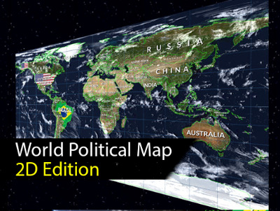
World Political Map - 2D Edition adds to your scene a beautiful, customizable and interactive 2D political map in just a couple of clicks. Drag the map into the assembly on the stage and adjust the appearance.
Key feature:
* Procedureally attracts the borders of 241 countries, 4112 provinces and states and the location of 7144 most populated cities in the world!
* Fully interactive map: zooming, panning, selecting, regions of countries, provinces / states and cities are highlighted when you skip the mouse over them.
* Viewport rendering goals (supports cropping, see Video below for demonstration)
* Support for prospective and orthographic forecasts
* Add markers and animation lines to any country, province, city or custom, using latitude / longitude
* Can be created and managed by code (API and provided documentation).
Custom editor-inspector with 4 additional amazing components:
* Calculator: unit converter from lat / lon to XY coordinates and city distance calculator.
* Tickers: scrolling, flashing and fading messages.
* Decorator: customize the appearance of countries (colors, textures, labels).
* Map editor: build the necessary map from the Unity editor with the help of advanced tools (create / change / change / combine countries, provinces, cities ...)
Additional features:
- Three types of cities, including the capital of the country and the region.
- Automatically draws country labels with layout options.
- Colorize countries, provinces / states or entire continents!
- To support the texture in the country!
- Find and swim in any country, state or city by name from the current position. Also find / fly to any place on the map in latitude / longitude.
- Mount Points: add your custom strategic locations from the editor and easily find / move / position the objects.
- Two levels of detail for the boundaries in the scale of 110.00.000: 1 and 30.000.000: 1.
- Imaginary lines: dial latitude, longitude and cursor line.
- Many options for customization: border colors, highlight color, visibility of cities / borders / Earth, shortcuts, ...
- 8 earth styles from light styles to advanced styles, including Scenic shaders (clouds + relief effects) and textures with high resolution up to 16K with custom shaders.
- Internet is not required! Geographic data included in the asset that Google Maps does not use, and no other card provider. It makes it very fast and works offline!
- Mobile cellular: tested on Android and iOS.
- Source code is enabled (C #).
- Special support forum.
[Ссылки доступны только зарегистрированным пользователям
. Регистрируйся тут...]
Bit depth: 64bit
Language: English
Tabletka: not required
System requirements: Unity 5.1.1 or higher
Download Unity Asset - World Political Map - 2D Edition v5.9.3 x64 from here:
DOWNLOAD
Код:
http://nitroflare.com/view/B1F13359F6BBE96/ansty.rar
Код:
http://rapidgator.net/file/7b660111f99d6b3378a42fc561cc0f70/ansty.rar.html
Код:
http://turbobit.net/i4ysyonerkf0/ansty.rar.html